2.1 Natural Environment The natural environment of the study area
in each country is indicated in Table 1. It is described in more details below. Table 1 Summary of Natural Environment of the Study
Area in Each Country
(1) Cote d'Ivoire The valley bottom (bas-fonds in French) along the river in the Djebonoua
district about 20km to the south of Bouake,
one of the main inland cities, served as
the study area. The area is at an altitude of about 330m. It belongs to the Kan River system, which
is the tributary to the right of the Nji
River, one of the three largest tributaries
of the Bandama River, and of which one of
the most upstream rivers is the Kplaha River. The width of valley bottom paddy fields around
the study area including slopes is 150-400m,
and 40-120m at the floor though close to
200m at some places. The relative height between the plateau and
the valley floor is 8-10m. The inclination of slopes is 4-5% on the
left bank and 2-4% on the right bank. The soils' principal mineral is quartz,
its clay kaolinite, and its color generally
reddish due to the quartz thinly coated with
iron film. The soil textures belong
to sand and sandy
loam. The soils of the plateau are
classified as Paleustults and Kandiustalfs, of the slopes
Ustropepts and Dystropepts, and of the valley
bottoms Fluvaquents. Since the parent material of these soils
is weathered granite, their fertility is
generally low. The soils' low fertility is indicated in
the results of an experiment conducted as
part of the study (Table 2). This
experiment was for examining the effects of the three major nutrients (N, P
and K),
and many suggestive findings were obtained. Table 2 Fertilizer Application
Experiment (on Paddy
Rice) in Cote d'Ivoire
* Yield at paddies overgrown with weeds due to water shortage was only 1.4 ton/ha. Yields in unhusked weight. It is recognizable that crop yields increased
on average by the use of the chemical fertilizers. However, yields varied widely between the
experimental fields. This may be because paddies that were of
high potential yields and those that were
not existed side by side in the area where
the experiment was conducted at the valley
bottom. Since the available phosphate (P2O5) content was low at the low yield paddies
in the first experiment, a section with a
doubled amount of P2O5 was added in the second experiment. However, its effects on crop increase were
not so high, for the average yield of the
control section was 4.5 ton/ha and that of
the doubled P2O5 section 5.3 ton/ha. From this result, the low yields cannot be
attributed to phosphate deficiency. That is, it suggests the possibility that
there are other soil factors, which limited
the yields besides the three major nutrients. As for the climate, the area belongs to the
Guinea savanna zone. The dry season and the rainy season are clearly
divided, and the rainy season lasts from
April through October and the dry season
November through March. Annual average precipitation is about 1,100mm,
of which close to 85% concentrates in the
rainy season. Annual average temperature is between 24.3° C and 28.3° C, and it is hottest from February
to March at the end of the dry season. Sunshine
hours are 7.7 hours a day on average in January and February of the dry season
but are only 2.7 hours on average in August
of the rainy season, and are 5.6 hours on
average throughout the year. (2) Tanzania The study was conducted at the valley bottom
(mbuga) in Chekereni Weruweru village about
5km southwest of Moshi City, the capital
of Kilimanjaro region, located at the south
base of Kilimanjaro volcano. The area's altitude is about 800m. Located at the mountain toe of Kililmanjaro
volcano, its overall inclination is slightly
over 1%. Several springs are found at this valley
bottom, of which the water volume increases
toward the end of the rainy season, but the
water yield, even totaled, is very small. On the other hand, the Kiladeda River, the
main source of irrigation water for rice
paddies of about 20ha spreading across the
valley bottom, which runs southward about
200m west of the paddies along the slope
of the entire volcano base, often floods
during the rainy season, and overflows pour
into the valley floor. From the conditions of the area, it is very
likely that the valley was formed by overflows. The valley bottom paddy fields are about
1km long north and south, and about 300m
wide at its widest upstream to the north
with a narrow section 20m wide about three
quarters down from the top, which becomes
wider again about 120m wide downstream. The highland has undulations and the relative
height from the valley floor varies. There are small hills about several meters
high to the north and the west and about
10m high to the east of the narrow section. Further, there is the Njoro spring that has
considerable water volume about 400m to the
east of downstream of paddy fields. The parent material of the soil is aeolian
andesite volcanic ash. Since the area is semiarid with little precipitation
and dry and rainy seasons, volcanic ashes
are weathered to become halloysitic and the
soil so produced is presumed to be fertile
Paleustolls. The soil's high fertility was evident in
the results of the fertilizer application
experiment conducted as part of the study
(Table 3). Table 3 Fertilizer Application Experiment (on Paddy
Rice) in Tanzania
Note: Weighed unhusked. Nitrogen was divided equally to basal application (2 weeks after planting) and additional application (2 weeks before heading). The other nutrients were applied with basal fertilizer. The field without fertilizer application
produced unhusked rice yield of 3 ton/ha,
which increased up to 7 ton/ha only with
the nitrogen fertilizer. Even compared to the experimental results
in the other countries, the soil fertility
of this area is overwhelmingly high. In the neighboring districts under the Kilimanjaro
Agricultural Development Project (KADP) implemented
in the 1980's with assistance of the Japanese
government, high yields exceeding 6 ton/ha
have been maintained over 10 years only with
nitrogen application. However, there is sodium accumulation in
the subsoil of this area. If topsoil treatment were done inappropriately
during paddy field development, salt damage
might ensue, and thus caution should be in
order. This point will be referred to later. As for the climate, the rainy season is from
December to May and the dry season from June
to November, and the annual average precipitation
is small at 600-900mm. Having mountain climate characteristics,
it tends to rain more the closer to the slopes,
and annual precipitation reaches 2,000mm
at the middle slopes of Mt. Kilimanjaro. Rainfall to this mountain turns into springs
at its base, putting crop production in the
study area and the surrounding valley bottoms
at advantage. However, the sodium content of the spring
water may be excessively high depending on
the springs and as there have been sporadic
reports of salt damage due to the high sodium
content, attention should be paid to the
quality of water. The annual average temperature is between
21.8° C and 27.3° C and the range is relatively
wide. Temperature increases during the rainy season
and reaches highest in February and March. It cools down during the dry season, and
especially from July to August the lowest
temperature may reach as low as about 10° C. (3) Zambia The study area is the valley bottom (dambo)
formed upstream of the Chambanshi River about
40km north of Kasama, the capital of Northern
region, which is about 800km northeast of
the nation's capital of Lusaka. The altitude is about 1,300m. The Chambanshi River is a tribute of the
Chambeshi River about 100km to the east of
Kasama City, which runs to the southwest,
but its water volume is very small. The valley bottom spreads long and narrow
along the stream of the Chambanshi River,
and the right bank is about 200m wide and
the left bank about 50m at the study point. The valley bottom, which is almost totally
unutilized, is grassland. Its highland is woodland, called Miombo woodland,
of very simple appearance with legume trees
(under 10m high), which gently slopes down
toward the river. If only the grassland is regarded to constitute
the valley bottom, the relative height from
the river does not exceed 10m. The principal mineral of the soils of the
plateau is mainly quartz sand. For this quartz sand is accompanied by kaolinitic
clay with its quartz thinly coated with iron,
the soils' appearance is reddish. The soils are Kandiustults and Paleustults
with a laterite horizon in the substrata
as a common characteristic. For topsoil, the section near streams in
the valley bottom has peat and that close
to the Miombo woodland at somewhat higher
relative height has a mucky humus horizon. While the principal mineral of these soils
is quartz, having almost no iron coating,
their color is grayish pink. Their classification is sandy Fluvaquents,
and considered to be Hystic Fluvaquents near
the flat valley bottom. Since the soils were formed over a geochronologically
extremely old shield, their fertility is
very low. Various nutrients may be lacking, including
not only the three major nutrients but also
such nutrients as sulfur, magnesium, boron,
and others, and even minor nutrients.[1]
These are suggested by the results of the
fertilizer application experiment conducted
as part of the study (Table 4) and through
observations of the crops grown in the fields
and sold at markets. Table 4 Fertilizer Application Experiment in Zambia
Note : Three nutrients were applied by chemical fertilizers that did not contain S. S applied was simple sulfur as specified by the Japanese Pharmacopoeia. The yield from Without-S field for paddy rice is the average of two treatments, with or without land leveling. No leveling was done for With-S field. The amount of fertilizer applied and the farming methods followed the customary practices of the local farmers. Yieldsmeasured with husks for paddy rice and by grain weight for maize. Regardless of treatment, the yields of both
paddy rice and maize are extremely low. This strongly indicates the unusually low
natural fertility of the soils. Also, the effects of sulfur application on
crop yields are quite evident for both paddy
rice and maize. Especially for paddy rice, the yield at the
field in which sulfur was added reached 2.3
times as high as when only the three nutrients
were applied. It is apparent that the soil of every field
is lacking in sulfur. Moreover, a study on various crops growing
around the area and vegetables sold at markets
suggests that there are other nutrients such
as boron, zinc and magnesium lacking in this
area's soils besides sulfur. The area's climate is clearly divided into
the dry season and the rainy season; the
rainy season from November to April and the
dry season for the rest. Annual precipitation is about 1,100mm, of
which close to 90% concentrates during December
through March. Further, there is practically no substantial
rainfall from May to October. As for temperature, the annual average is
about 20° C, and the monthly average is the
highest in October at 23.3° C and the lowest
in July at 17° C. (4) Malawi The study area is the valley bottom (dambo)
in Bandawe village of Salima district, about
100km to the east-northeast of the nation's
capital of Lilongwe. This valley bottom, close to Lake Malawi
shore, is slightly over 1km long in the major
axis and about 400m in the minor axis. Reportedly, the area used to flood throughout
the year but it turned into a marsh as the
water level of Lake Malawi dropped. At its south end, the Nyungwi River runs
to the east and flows into Lake Malawi. During the rainy season, the water level
of the Nyungwi River rises and the overflowing
floods the valley bottom. However, during the dry season, the groundwater
level drops and the ground dries up to the
point of cracking. The valley bottom is in the shape of a shallow
dish and the relative height to the surrounding
areas is about 2m. The soil is Vertisols of sandy loam and its color is close to black. The soil of the flat valley bottom is fairly fertile, but as it turns more coarse sandy loam toward the upper section of the slope, fertility in the usual sense decreases. The results of the fertilizer application experiment at the flat valley bottom are presented in Table 5. Table 5 Fertilizer Application Experiment in Malawi
Note: Experiment with paddy rice; the variety TCG10 (Mtupatupa in the local language); potential yield about 6 ton/ha. Fertilizers applied are compound fertilizers and urea, all of which were applied as basal fertilizer. Yields in unhusked weight. The effects of the fertilizer applications
are evident, but even without the fertilizers
the yields are relatively high. However, in the condition without fertilizer,
the timing of heading was delayed for about
20 days, suggesting that growth retardation
occurred. This might have been caused by phosphate
deficiency. The area's climate belongs to tropical savanna,
and annual precipitation is slightly less
than 1,200mm, of which 90% concentrates in
December through March. Further, there is almost no rainfall from
June through October. Annual precipitation has fluctuated between
600mm and 1,900mm in the past 11 years. Temperature averages 25° C throughout the
year. It is the hottest in January with the monthly
average temperature at 32° C for the highest
and 24° C for the lowest, and the coolest
in June and July with the monthly average
temperature at 27° C for the highest and
17° C for the lowest. As for the sunshine hours, October has the
longest at 10.1 hours per day on average
and January the shortest at 5.6 hours. Annual hours of sunshine are 8.7 hours per
day on average. 2.2 Issues on Agricultural Development in Relation
to Climate and Soils (1) Climatic Environment The division of the rainy season and the
dry season is clear in every one of the areas
studied. The rainy season is brought by rainfall caused
by the north-south movements and the onset
of the intertropical convergence zone (ITCZ). However, because the movements are irregular,
the timing of the beginning and end of rainfall
is not necessarily fixed and the amount of
rainfall is apt to fluctuate as well. Further, due to the influence of the ascending
current inland, heavy rains occur at times. These annual fluctuations related to the
timing and amount of rainfall and heavy rains
work against agricultural production. As for hours of sunshine, the lack of sunshine
during the rainy season could be a negative
factor of crop production in Cote d'Ivoire. Meteorologically, in every study area the
monthly average temperature is in the 25-30° C
range and even the lowest temperature is
generally over 20° C during the rainy season
that is the time of crop cultivation. Therefore, the likelihood of temperature
negatively affecting crop cultivation in
the rainy season is nil. On the other hand, in the dry season there
is no rainfall and water is a limiting factor
of crop production, but hours of sunshine
are long and there are many advantageous
conditions for crop production. For example, in the eastern and the southern
Africa where altitudes are generally high,
the lowest temperature during the dry season
drops below 20° C allowing cultivation of
temperate zone crops. In terms of water environment, inland valley
bottoms are endowed compared to highlands,
for even during the dry season there is surface
water and groundwater levels are high. Thus, it may be argued that crop production
potentials at inland valley bottoms are high
in that water resources development is easier
at relatively low cost. (2) Soil environment By and large, the fertility of African soils
is low. This has been recognized anew in the recent
years, and the International Workshop on
Development of National Strategies for Soil
Fertility Recapitalization in Sub-Saharan
Africa was held in April of 1997 under cosponsorship
of the World Bank and the International Fertilizer
Development Center. At this workshop, it was recognized that
soil fertility improvement would play a very
significant role in agricultural advancement,
rural development and environmental conservation
in Sub-Saharan Africa, and it was confirmed
that implementation of soil fertility improvement
would be reflected in every country's national
action plan. The soil environment of the study areas especially
in terms of fertility is explained below. (i) Low fertility and low productivity of
African soils The reasons for the low fertility of African
soils are outlined as follows. The African continent is geologically very
old and has never been subject to diastrophism
such as upheavals and subsidences for the
past several hundred million years. Erosion cycles in the geological sense have
repeated countless times during the period,
turning it into a plateau continent. As a result of eons of erosion and weathering,
the residual soil mineral is quartz that
is most resistant to weathering. Of the study areas in the four countries
examined, the soils' principal mineral was
quartz (silicon dioxide) except the soil
in Tanzania, which was formed by fallen ash
from Kilimanjaro volcano to be described
later. An ordinary mineral has aluminum, iron and
silicon as main constituent elements, and
such minerals are apt to contain metallic
elements essential for plant growth as they
are attached to iron. However, in Africa dominant are quartz-based
soils with aluminum and even iron leached
out, which are less likely to contain essential
elements. Therefore, the effects of fertilizer application
generally tend to be marked, as mentioned
previously, as observed in the experiments
conducted in each country. Because of the low soil fertility, element
deficiency diseases were observed in various
crops across the areas examined, but sulfur,
boron and zinc deficiencies were especially
noticeable. In particular, the occurrences of symptoms
of sulfur deficiency and minor elements deficiencies
were widespread in Zambia. In the country, liberalization policies by
IMF and the World Bank were put into effect
in 1992, and all the restrictions on import
of fertilizers, which had been generally
under the government's control, were abolished
making it possible to import and sell any
kind of fertilizer freely. As a result, the import of cheaper fertilizers
of only NPK compounds increased dramatically. As of 1997, the final year of the study,
according to the only fertilizer trader (House
of Kasama) in the central city of Kasama,
no NPK fertilizer containing sulfur had ever
reached the store for six years since 1992. It was only 1999 when its import started
again. As seen from the results of the studies conducted
by the study team, it is not hard to imagine
how grave the farmers' losses must have
been in this period. The unavailability of these fertilizers is
apparently beyond the local farmers' control,
and also it cannot be denied that the central
government's administrative capacity (and
the lack thereof) has had very serious effects
on the development of individual farmers
as well. Moreover, soil fertility is often discussed
with reference to organic matters and humus
in soil, and humus normally becomes stable
as it combines with metallic nutrients such
as aluminum and iron. However, in case of soil with quartz as the
principal mineral, humus decomposes and disappears
very rapidly because of its free condition,
and thus the accumulated effects of humus
through compost and such cannot be expected
in the long run. The aforementioned is generally applicable
to soils in not only inland valley bottoms
but also Africa as a whole. The regional distribution of element deficiencies
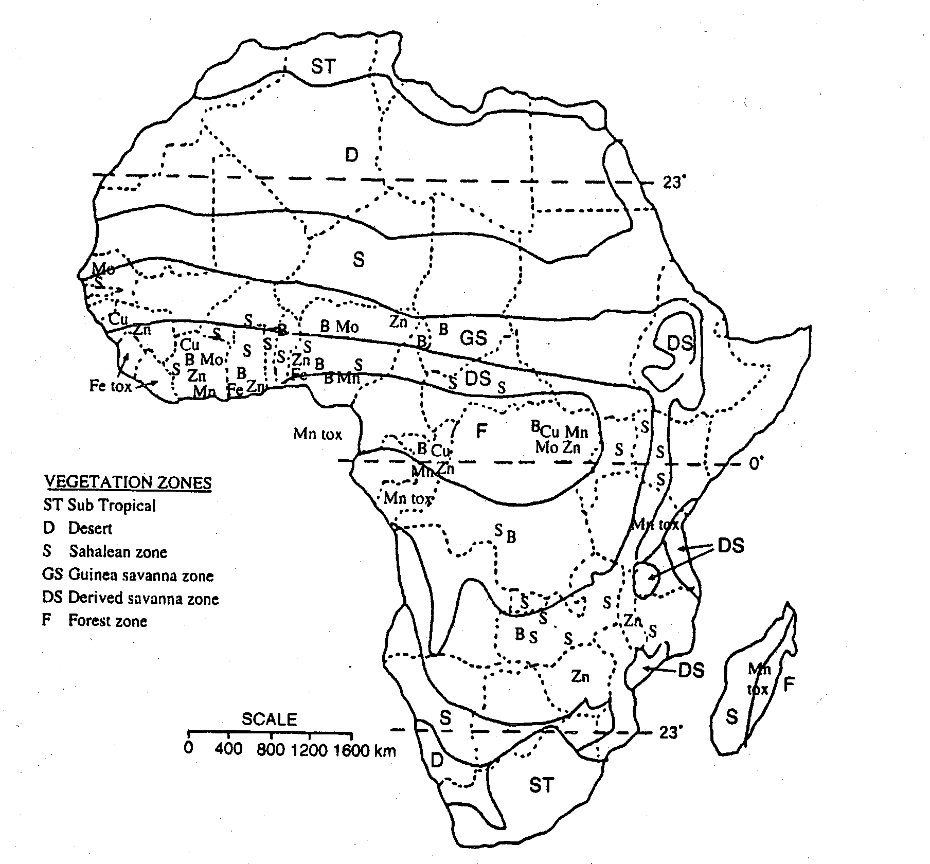
and toxicity in Africa has been reported
as shown in Figure 2.
Figure 2 Locations
of Micronutrients Deficiencies
and
To improve crop yields, soil fertility improvement
is essential including fertilizer application. However, unfortunately the consumption volume
of chemical fertilizers is merely 19kg/ha
in the entire Africa. That is only one fifteenth (1/15) of 287kg/ha
in Japan. (ii) Characteristics of inland valley bottoms As characteristics of the general shape of
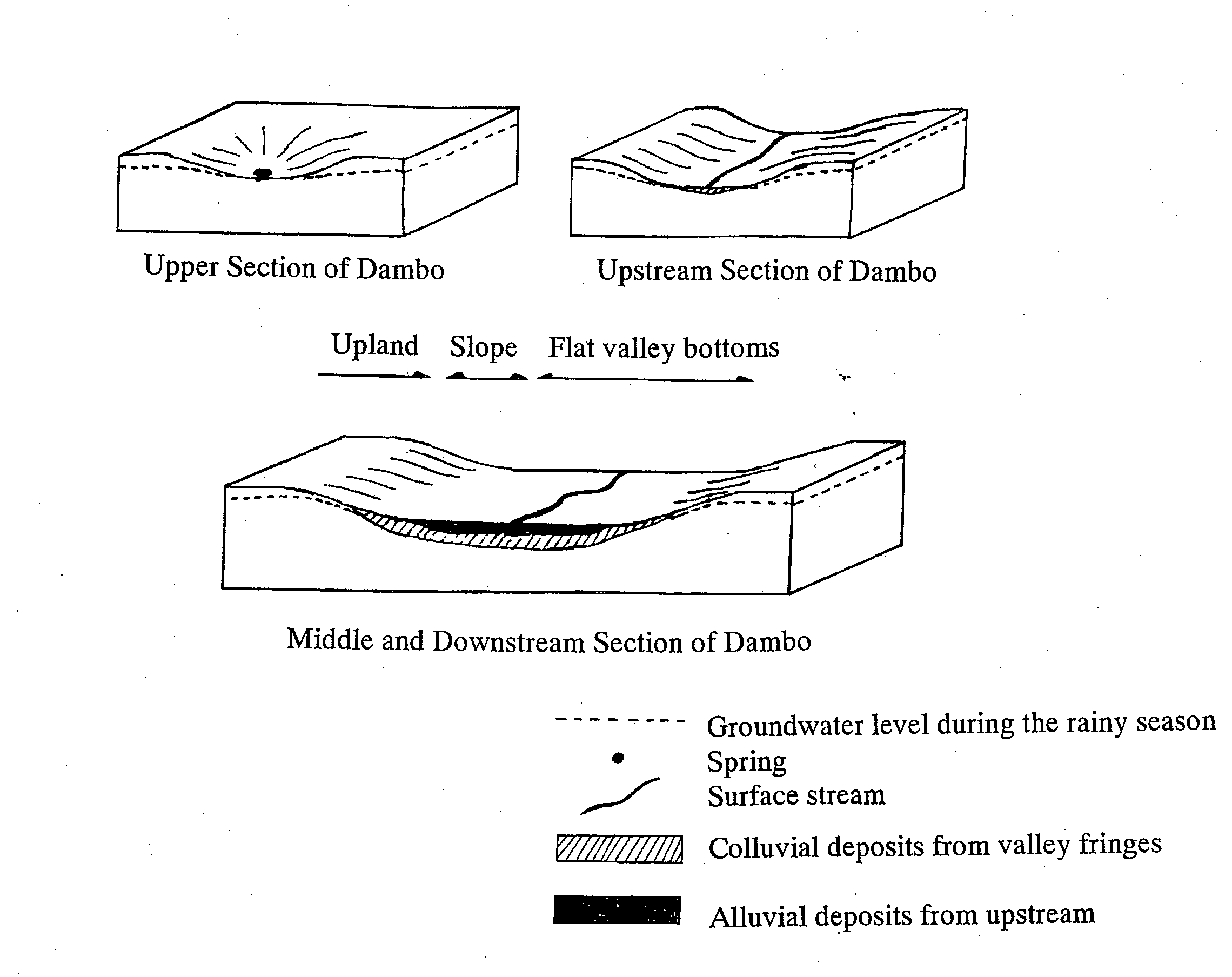
an inland valley bottom, first the vastness
of its highland plateau may be noted (Figure
3). Valley bottoms, though reflecting the stability
of the African continent as a continent,
occupy only a part of the tectonic flat topography. Also, the inland valley bottom is formed
into the topography of an oval, shallow dish,
for the rivers flow gently from upstream
to downstream. The gentle slope of the dish-shaped topography
is on the fringes of a sloping valley of
eroded morphology and thus the substrata
of the upland soil are exposed. Further, in case of the valley bottom farthest
upstream where the flow of rivers is extremely
gentle, there may remain stagnant water during
the dry season for a while at times, and
under such conditions peaty soils may form
at the bottom of the concave.
Figure 3 Shapes of Inland Valley Bottoms: Models
(iii) Fertile volcanic ash soil and salt
damage In the Great Rift Valley region of the geologically
old African continent, soils are generally
fertile because there are many volcanoes
leading soil rejuvenation to occur with their
eruptions, and being in a semiarid zone,
volcanic ashes form soils through the halloysitic
weathering process. The southern mountain foot of Kilimanjaro
volcano, one of the study areas, is part
of the Great Rift Valley. The area's soil is no exception, very fertile,
and crop yields are very high compared to
the other areas as shown in Table 3. Yet, salt damage (sodium damage) was detected
in paddy rice as an idiosyncratic problem
to this area, and the reason for this problem
is discussed below.[2] The sodium content of the soils in this area
becomes higher the deeper into the substrata. At places where subsoil had been exposed
by cutting when paddy fields were developed,
the rice growing there showed signs of saline
damage. Also, there are some springs and rivers around
the area with water high in sodium, and from
irrigating paddies with those as water sources
saline-damaged paddy may ensue. Further, at paddies that were not filled
with water due to water shortage, cases were
observed, in which rice received salt-related
damage. In these cases, sodium in the soil or the
irrigation water became accumulated in the
topsoil, accompanied by evaporation of water
from the exposed soil. The high sodium concentration in the soil
and rivers/springs in this area was presumed
to have resulted from lava runoff from Ol
Doinyo Lengai volcano about 100km to the
west-northwest of Kilimanjaro volcano. The major nutrients of the chemical composition
of ordinary lava flow and extruded volcanic
ash are silicon, aluminum, iron, and others. However, the lava runoff from the volcano
in October 1960 revealed that the lava flow
of Ol Doinyo Lengai volcano contained almost
none of these nutrients but instead was mainly
composed of sodium and carbon dioxide. In other words, it is speculated that volcanic
ashes with sodium carbonate as the main constituent
fell to this area in large quantities prior
to the ash fall from Kilimanjaro volcano,
which forms the present ground surface. This explains both the salt damage derived
from soil as well as the salt damage derived
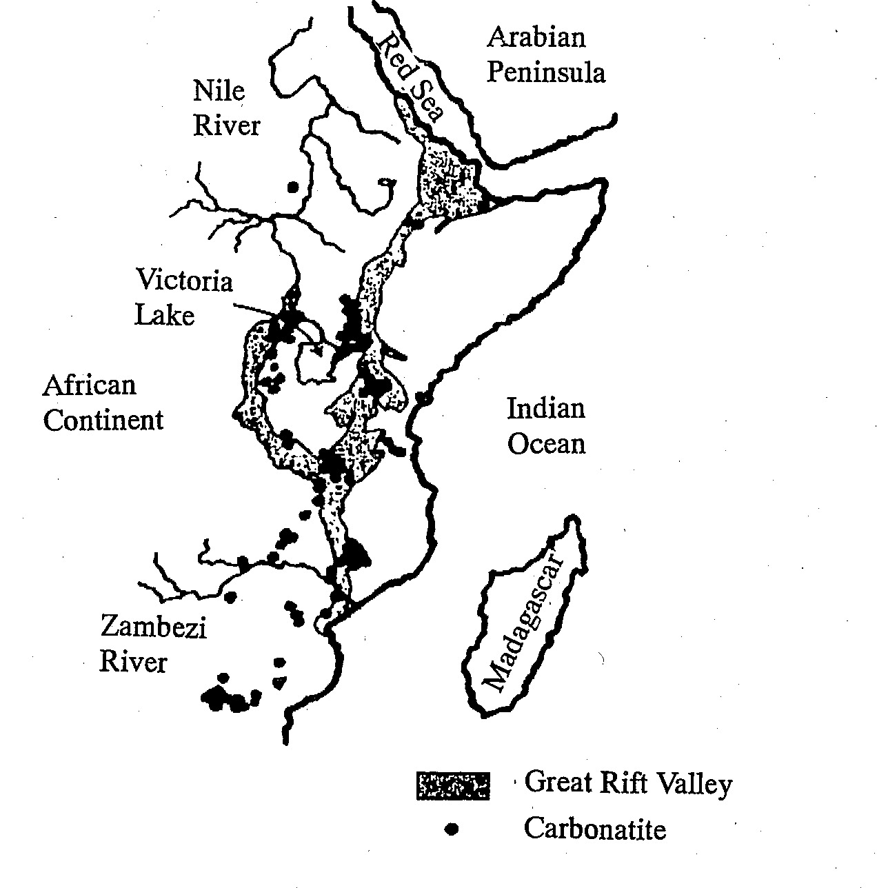
from irrigation water in this area. The mineral of this type of composition is
called carbonatite and there are 330 volcanoes
in the world that have been known to produce
carbonatite. Of these about a half are found in Africa,
the majority of which in turn are distributed
in and around the Great Rift Valley (Figure
4). Hence, at areas in which carbonatite originates,
it is necessary to measure sodium concentration
in soils and river/spring water, calculate
not only pH or EC (electric conductivity)
but also SAR [3] (sodium adsorption ratio) considering the
dissolution characteristics of sodium carbonate
(i.e., relatively moderate pH increase and
moderate EC), and take appropriate measures
against salt damage. Figure 4 Distribution of Carbonatite around the Great Rift Valley
|